Seismic imaging: a 3-step process
Similar to sonar, seismic imaging (or reflection seismology) is a high-resolution non-invasive technique in which seismic waves - more commonly known as sound waves - are employed to produce accurate maps of the subsurface. When such waves propagate through the ground, they interact with the internal structure of the Earth and allow us to identify and localize features of various scales such as the core-mantle boundary location, giant meteor craters, earthquake source locations, and geologic traps for hydrocarbon reservoirs.
For the past 50 years, seismic imaging has been the most exploited and effective method for hyrdocarbon exploration. Energy companies rely on having good-quality seismic images to ensure safety and efficiency during the drilling and production process.
However, this task can be quite challenging to achieve in certain parts of the world where complex geological settings are encountered. Therefore, companies have invested considerable amount of resources in research and development to design cutting-edge imaging algorithms aimed at improving our knowledge of the subsurface. This is in fact the main motivation of my thesis work! But examining the more advanced algorithms, let's try to understand the standard approach.
Click on the icons below to learn more about each topic
⬇⬇⬇
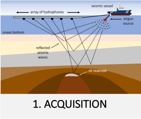

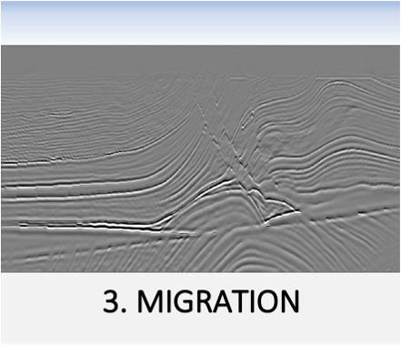
The conventional seismic imaging workflow conducted by energy companies to assess the structure of the Earth (and potentially identify hydrocarbon resources) is composed of 3 main steps, as listed below. However, current methods present some limitations that I try to address in my thesis. Click on any of the links (or the icons on the figures above) to learn more about each one of them:
- Seismic Data Acquisition
- Velocity Estimation
- Migration
- Limitations of current methods
- FWIME: my dissertation work